About Les Pérics 09-66 Rando3D
The Pérics - Orlu - Bouillouses Ariege 09 - Pyrenees Orientales 66 3D map of Font Viva sector - Worn-Puymorens Les Angles and Orlu in Mijanès LIST OF HIKING 1 - Pic of Man from the valley of Orgeix
The Pérics - Orlu - Bouillouses
Ariege 09 - Pyrenees Orientales 66
3D map of Font Viva sector - Worn-Puymorens Les Angles
and Orlu in Mijanès
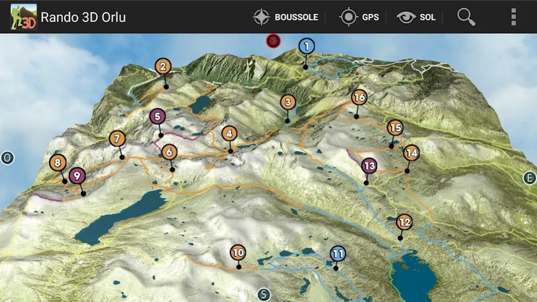
LIST OF HIKING
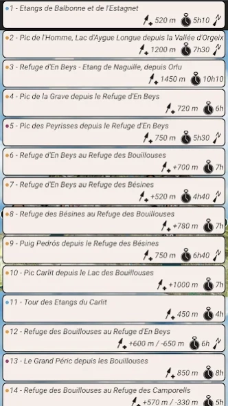
1 - Pic of Man from the valley of Orgeix
2 - Ponds Balbonne and Estagnet
3 - Refuge En Beys - Pond Naguille from Orlu
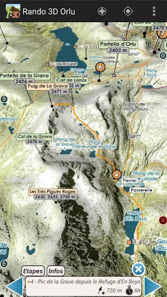
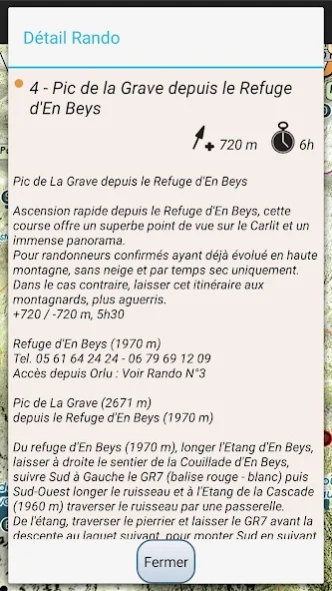
4 - Peak of La Grave from the refuge En Beys
5 - Pic de l'Etang Faury, looping from the Refuge to Beys
6 - En Beys Refuge - Refuge Bouillouses
7 - Refuge En Beys Refuge Bésines
8 - Bésines Refuge - Refuge Bouillouses
9 - Puig Pedrós since Refuge Bésines
10 - carlit from Lake Bouillouses
11 - Ponds Carlit
12 - Bouillouses Refuge - Refuge En Beys
13 - The Grand Péric
14 - Bouillouses Refuge - Refuge Camporells
15 - Camporells Refuge - Refuge En Beys
3D Hiking Guide
interactive and immersive application.
Take full advantage of this embedded hiking guide and map realistic.
The description of routes is detailed in dynamic 3D illustration.
All features are easy to use and accessible OFFLINE mountain oblige.
Good hiking at all.
IMMERSIVE 3D FEATURES
○ intuitive and precise controls ... fingertips.
○ Aerial View, overview
○ View and taxiing
○ Compass
○ Geolocation
& DESIGN GUIDE
○ precise descriptions, text and visuals
○ Steps
○ Live View in 3D
GPS
The GPS of your phone is used for geolocation on the map area, it is particularly useful to see its position in the terrain, especially in poor visibility on the ground.
COMPASS
The compass mode is integrated in 3D, the cardinal points are oriented according to the manual movements or map automatically orients the north by activating the compass mode directly from the 3D.
RELIEF IN SIGHT & 3D SOL
The aerial view and floor to illustrate the general view raised to a level of precision optimized, it is displayed on the screen depending on the definition of the relief and texture chosen to launch the application automatically loaded or select according to device capabilities used.
The movement of the floor camera can appreciate the details of the route to follow and total immersion in the relief.
TRACKS
In addition to the described hiking trails mapped known, variations and alternative routes, you can import your GPX tracks in the 3D map.
3D Interactive Application hiking guide - Facing the South TOPOMAP3D ® ® www.faceausud.com
Trademark and patented models 486299 08082013 - 12 3953606 © All rights reserved - No copying
With the kind of Helge Foerster JPCT 3D engine ® www.jpct.net Copyright © 2010
Previous Versions
Here you can find the changelog of Les Pérics 09-66 Rando3D since it was posted on our website on 2023-04-13 12:17:34.
The latest version is 1.0 and it was updated on 2024-04-22 10:48:43. See below the changes in each version.
Les Pérics 09-66 Rando3D version 1.0
Updated At: 2015-05-13
Disclaimer
Official Google Play Link
We do not host Les Pérics 09-66 Rando3D on our servers. We did not scan it for viruses, adware, spyware or other type of malware. This app is hosted by Google and passed their terms and conditions to be listed there. We recommend caution when installing it.
The Google Play link for Les Pérics 09-66 Rando3D is provided to you by apps112.com without any warranties, representations or guarantees of any kind, so access it at your own risk.
If you have questions regarding this particular app contact the publisher directly. For questions about the functionalities of apps112.com contact us.